Map of Asia Minor or Anatolia Map
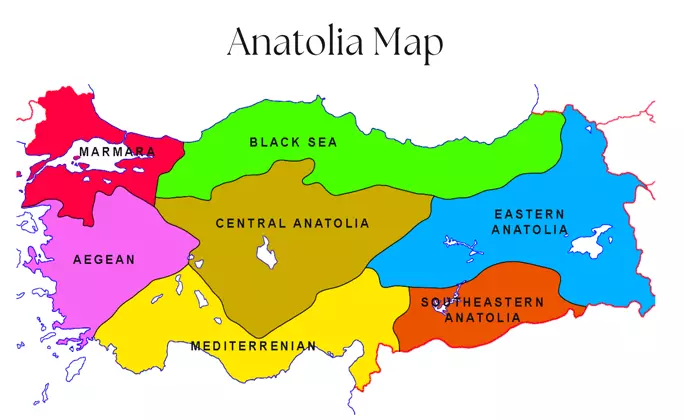
Called Anatolia or Asia Minor, it is the land of Turkey in the Asian continent of today. It is very important as it connects Anatolia, Asia, and Europe with the Bosphorus. We will refer to the article as Anatolia in one part and Asia Minor in the other. Please note that they are both in the same place. Let’s start with the Map of Asia Minor or Anatolia Map.
Anatolian lands have very fertile soil. It has also been a very popular location throughout human history, as it is at a point connecting Asia and Europe. For these reasons, the Anatolian map has changed constantly.
It is thought that Göbeklitepe in Anatolia was the first religious center and Çatalhöyük was the first settled city based on agriculture. The seven churches mentioned in the Bible are in Anatolia.
Let’s take a look at the history of this historical and very important location for humanity, the ancient city maps of Anatolia, and the empires built on it.
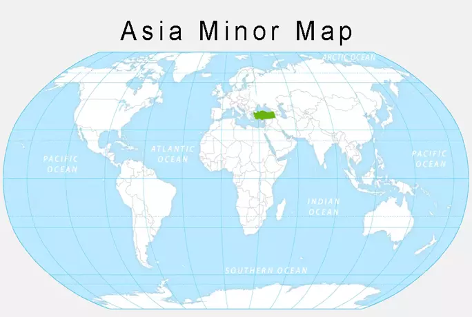
Anatolia map
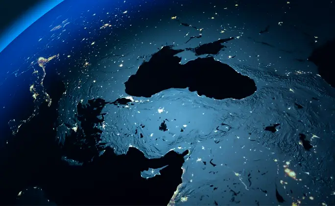
Map of Anatolia is the land in the Asian part of modern Turkey today. The westernmost is the city of Çanakkale, and the easternmost is the city of Iğdır. Hatay City is located in the southernmost part.
It is also called the Asia Minor peninsula because it is surrounded by seas on three sides. It has the Aegean Sea to the west, the Black Sea to the north, and the Mediterranean Sea to the south.
Today, there is the Republic of Turkey in the Anatolian lands. The south of Anatolia is known as Mesopotamia and its neighbors in the south are Iraq and Syria. Its eastern neighbors are Georgia, Armenia, Azerbaijan, and Iran. In the west, Greece and Bulgaria are the neighboring countries of Asia Minor.
The Asia Minor region, which has had a very important place throughout the history of humanity, maintains its importance today as it is close to oil countries, has an important sea coast like the Mediterranean, and is a neighbor to Russia through the Bosphorus and Dardanelles.
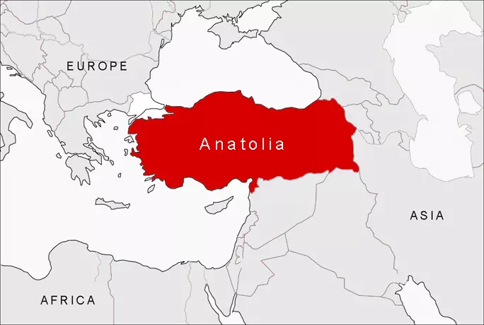
Ancient Asia Minor map
Anatolian lands have hosted many civilizations and empires. Many firsts for humanity have been experienced here and it has a very important place in human history. Let’s look at the important Anatolian civilizations and the Ancient Asia Minor map together.

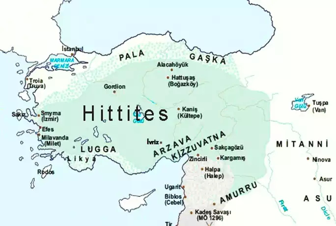
Asia Minor ancient Hittites map
The Hittites, who are thought to have come to Anatolia from the Caucasus in the 1600s, are known as the first state established in Anatolia. The capitals of the state established around the Kızılırmak are HATTUSAŞ (Boğazköy).
The Treaty of Kadesh, which the Hittites signed after the war with Egypt, is the first written agreement in history.
In the Hittite civilization, there was a council called Pankus and it limited the powers of the King. Despite this, the most authoritative person after the king was the queen.
Hittites started impartial historiography by preparing the annuals they called “ANAL”.
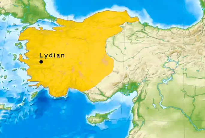
Lydian Civilization in Anatolia
The Lydians, the first civilization to use money, were very good at trade. The state established between the Gediz and Menderes rivers was instrumental in opening the KING Road, which started from Ephesus and reached Mesopotamia.
The Lydians had mercenaries from different tribes and did not have a regular army. It was occupied and destroyed by the Persians.
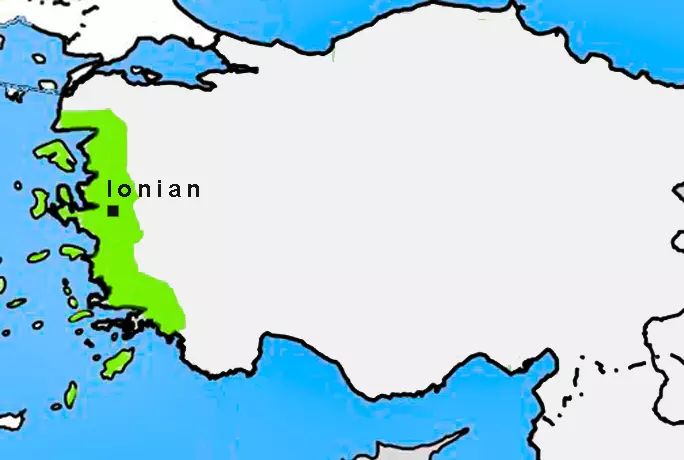
Asia Minor ancient Ionian map
Today, the Aegean Sea between Turkey and Greece is also known as the Ionian Sea and is named after this state. They lived in the gulf of Izmir to the gulf of Gulluk.
Major Ionian cities; Ephesus, Milet, Izmir, Foca, and Bodrum. The Temple of Artemis in Ephesus was built by the Ionians. The Ionian Anatolia map consists of these cities.
The Ionians, who were highly developed in maritime trade, were quite good at literature. The Iliad and the Odyssey epic by the famous Homer are the most famous.
Tales and Pythagoras in mathematics, Herodotus in history, Hippocrates in medicine, and Diogenes in philosophy are the gifts of the Ionians that have survived until today.
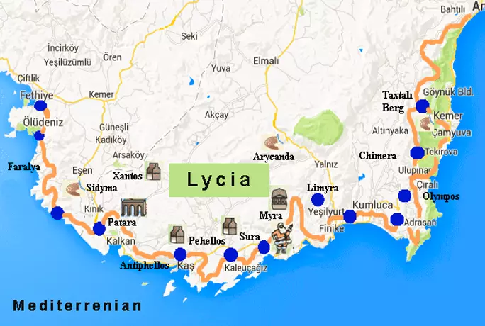
Asia Minor ancient Lycia map
The Lycian civilization, which was established between Muğla and Antalya today, is one of the important Greek city-states. They are very advanced in maritime trade and maritime.
It is one of the most important states ruled by democracy in history. It is claimed that while the American Constitution was being prepared, it was inspired by the laws of the Lycian civilization.
Patara Ancient City, Xanthos Ancient City, Phaselis Ancient City, Olympos Ancient City, Myra Ancient City, Letoon Sanctuary Place, and Antiphellos Ancient City in Kas are the works of this period.
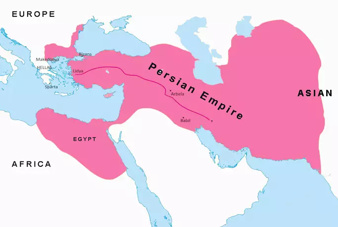
Asia Minor ancient Persian map
Persians ruled Anatolia for 200 years. They fought and taxed the Greek city-states. The region that is the subject of the movie is called 300 Spartans in western Anatolia. The Persians built the King’s road in order to move freely from east to west.
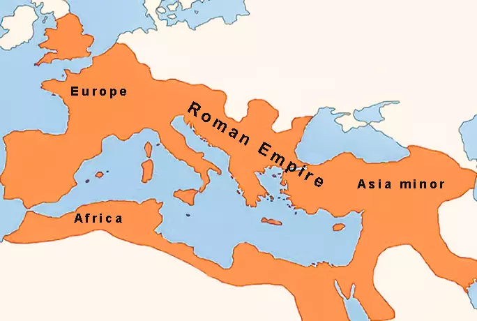
Asia Minor ancient Roman and Byzantine map
Many of the ancient cities you visit in Turkey were probably built during the Roman and Byzantine period, the continuation of Rome. The capital of the Eastern Roman and Byzantine Empires was Constantinopolis (Istanbul), and they ruled over a significant part of Anatolia.
Hagia Sophia(Hagia Sophia mosaics), Basilica Cistern, Hagia Eirene church, Bozboğan Arch, and Maiden’s Tower are some of the important works in Istanbul.
There are numerous Roman artifacts in Anatolia. The ancient city of Hierapolis in Pamukkale and the ancient city of Ephesus in Izmir are the most visited ancient cities by tourists.
Kaunos Ancient City, Knidos Ancient City, Magnesia ad Maeandrum, Metropolis Ancient City, Assos Ancient City, Gaziantep mosaics, Anemas Dungeons, Perge ancient city, St. Nicolas church, Hadrian’s Gate in Antalya Old Town and countless other artifacts.
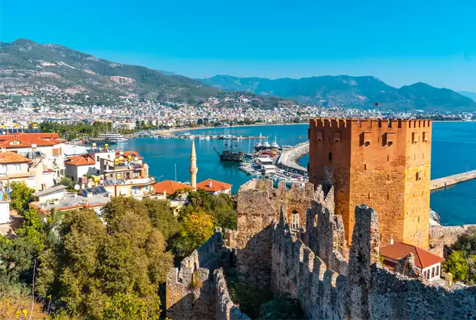
Asia Minor Ancient Seljuk Empire map
Another state that ruled Anatolia for 250 years is the Seljuk Anatolian state. It is the largest Muslim state in Anatolia.
The Seljuk empire left important works such as Alaeddin Mosque, Double Minaret Madrasa, and Alanya Castle.
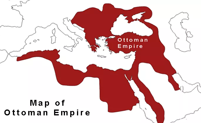
Asia Minor Ancient Ottoman Empire map
The Ottoman Empire was the last empire that ruled Anatolia until the First World War. Topkapi Palace, Blue Mosque, Selimiye Mosque, Rüstem Pasha Mosque, Ishak Pasha Palace, Seddülbahir Castle, and Ortaköy Mosque are the most well-known Ottoman works.
You can learn more about our Ottoman empire at its peak article.
Anatolian Religious Map
Anatolia or Asia Minor is a region that has had life throughout human history and has been an important geography for polytheistic religions, later Christianity and Islam.
Göbekli Tepe
Gobekli Tepe is considered to be the first religious center built by polytheistic people to worship. You can read more about Gobekli Tepe in Sanliurfa.
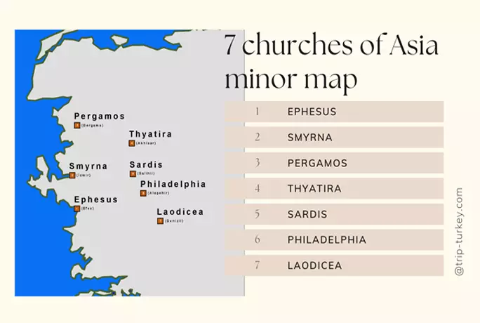
7 churches of Asia Minor map
It is the seven major churches of the Early Christian period mentioned in the Revelation section of the Bible. Today, the churches in the Aegean region of Turkey have symbolic importance for Christianity.
7 churches are in Ephesus, Izmir, Bergama, Akhisar, Salihli, Alaşehir, Batnaz and Denizli in Anatolia.
St.Nicolas Church
Also known as Santa Claus, St. Nicholas church is in the Demre region of Antalya. It is one of the cross areas for Christians. It was built in the Byzantine period.
Modern Turkey Anatolia map
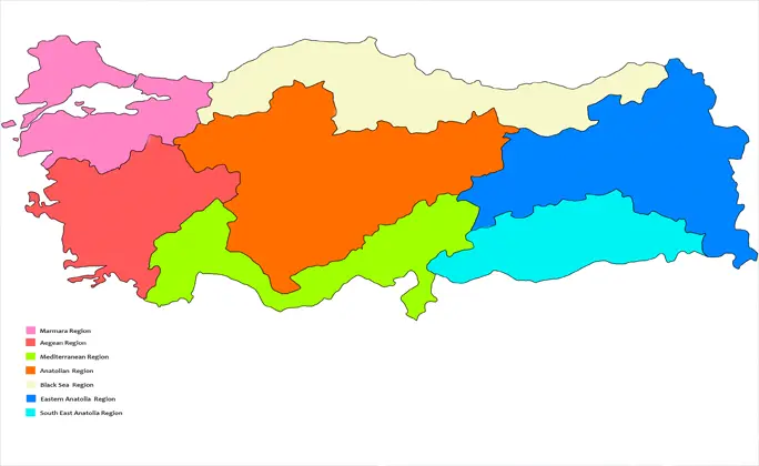
After the First World War, today’s Republic of Turkey was established. Turkey is divided into 7 regions. Marmara, Aegean, Mediterranean, Black Sea, Central Anatolia, Eastern Anatolia, and Southeastern Anatolia.
It has strategic importance with the Istanbul and Canakkale Straits. It is possible to find historical artifacts all over Turkey.
On the modern Anatolian Map of Turkey, Cappadocia is in Central Anatolia, Antalya is in the Mediterranean region, Izmir is in the Aegean region, Trabzon is in the Black Sea region, and Göbeklitepe is in the Southeast Anatolian region.
Turkey, which has a surface area of 783.562 km², is partly in the European continent and partly in the small Asian peninsula.
Anatolia map
Map of Asia Minor Frequently Asked Questions
How many km is Asia Minor on the map?
Anatolia is 783,562 km². The easternmost is Iğdır and the westernmost is Çanakkale.
Is Mesopotamia in Anatolia?
The geography known as Mesopotamia is a region in southeast Turkey, between Iraq and Syria. For this reason, yes, a part of Mesopotamia is in Anatolia.
Where is Asia Minor?
Asia Minor is located in the westernmost part of Asia and the easternmost of the European continent. It is the meeting point of Europe and Asia. Its neighbors are Bulgaria and Greece in Europe and Iran, Iraq, Syria, Armenia, and Georgia in Asia.
What is Asia Minor?
Asia Minor is a very important piece of land in terms of history and geography, combining the European and Asian continents. The peninsula, located in the westernmost part of Asia, is known as Asia Minor.
What sea is between Asia Minor and Greece?
Between Asia Minor and Greece is the Aegean Sea. It is also referred to as the Ionian Sea, used by Greece in the Hellenistic period, but Turkey does not accept it.
What Greek cities were in Asia Minor?
Important ancient Greek cities such as Troy, Ionian, Lydia, Lycia, and Pergamon were established in Asia Minor or Western Anatolia.
What countries are in Asia Minor?
Today in Asia Minor, there is modern Turkey. In history, many ancient Greek states hosted powerful states of the period such as the Roman and Byzantine Empires, the Seljuk state, the Hittites, and the Ottoman Empire.
Is Greece in Asia Minor?
Asia Minor is the geography known as Anatolia and ends on the east side of Istanbul. The European continent begins from the western side of Istanbul. In summary, no Greece is not in Asia Minor.
What are the seven churches of Asia Minor?
Seven churches are the churches of the first period of Christianity, which are mentioned in the Bible. It is located in the cities of Ephesus, Izmir, Bergama, Akhisar, Salihli, Alaşehir, Batnaz, and Denizli, which are located in the Western Anatolia of Turkey today.
What countries make up Asia Minor?
The region known today as Asia Minor is where the Republic of Turkey is located.
Where is Asia Minor on a map of ancient Greece?
The map of Asia Minor, ancient Greece is on the western side of Anatolia. The settlements of Greece are in the west of Asia Minor and in the east of the European continent.
Where is Anatolia in Turkey?
Although the region called Anatolia is used for the whole of Turkey today, it actually consists of Eastern Anatolia, Central Anatolia, the Black Sea, the Mediterranean, the Aegean, and the southern part of the Marmara region. The remaining southeastern Anatolian region is called Mesopotamia.
Continue reading;
If you are wondering more about Turks, you can check out our articles: Are Turkish people Arabic?, Map of Ottoman Empire at Its Peak, Sultan Suleiman the Magnificent, Traditional Turkish Dresses, Turkish Bath, Turkish Oil Wrestling, Traditional Turkish Coffee.
