Istanbul Metro Map and Transportation by Train 2023

Istanbul is Turkey’s most populous city since the peak period of the Ottoman Empire and therefore there is a lot of traffic. If you came to Turkey as a tourist and want to travel, using Istanbul public transportation is very important and it will give you a lot of speed. In this article, I will share with you public transportation, the Istanbul metro map, the Istanbul train map, and tram travel tips in Istanbul.
The city, which is divided into two by the Bosphorus, has a developed metro infrastructure on both sides of the city, where you can reach every part of it. There is also a train called Marmaray, which passes under the sea from the Bosphorus in Istanbul.
If you want to come to Istanbul as a tourist and use the metro or other means of transportation, you should purchase the Istanbul City Card for Tourists. You can read the details in this article.
Let’s take a look at the public transportation of Istanbul, which is one of the most livable cities in Turkey and hosts the most tourists.
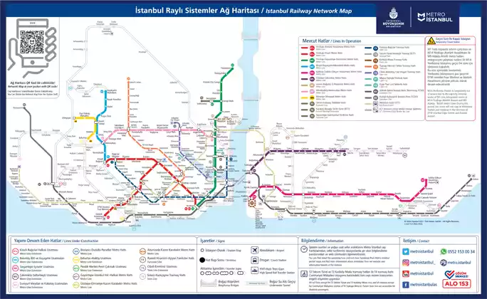
Istanbul Metro Map
Istanbul subway map has the most advanced metro map in Turkey.

👉🏻You can download the big image of Istanbul Metro Map from here.
👉🏻You can download Istanbul Metro Map as a pdf here.
Is Istanbul Metro safe?
You can take the metro, train, or tram in Istanbul with peace of mind. Everyone goes through X-Ray devices without getting on and there is security at the stations.
Transportation by Istanbul Metro and Metro Map
There are a total of four metro lines in Istanbul, two on the European side and two on the Anatolian side. These metro lines go to many places except the northernmost part of Istanbul.

M1 – Istanbul European Side Metro Line
The M1 metro line is one of the lines on the European side of Istanbul. It operates flights between Yenikapı and Atatürk Airport. Unfortunately, Atatürk Airport is no longer used, but this metro line is used extensively due to its proximity to Bakırköy.
The M1 metro line is divided into two within itself. You can take the short metro between Esenler – Bağcılar by getting off at the bus station. From Yenikapı stop, you can transfer to the Marmaray train and travel to the Anatolian side.
The M1 Istanbul metro line is 26 km, has 13 stations and the journey takes 25 minutes in total.
M1 Istanbul metro working hours are 06:00 – 00:00.
M1 Istanbul metro line route
- Yenikapi Station
- Aksaray Station
- Safety-Fatih Station
- Topkapi Ulubatli Station
- Bayrampasa-Maltepe Station
- Sagmalcilar Station
- Kocatepe Station
- Otogar Station
- Terazidere Station
- Davutpasa – YTU Station
- Merter Station
- Zeytinburnu Station
- Bakirkoy-Incirli Station
- Bahcelievler Station
- Ataköy-Şirinevler Station
- Yenibosna Station
- DTM – Istanbul Expo Center Station
- Ataturk Airport Station

M2 Istanbul European Side Metro Line Route
The M2 metro is the most used metro line in Istanbul. If you want to go to Taksim square, you can use this metro. This metro also passes through very good locations for shopping in Istanbul such as Levent and Nişantaşı.
The M2 Istanbul metro line is 24 km, has 16 stations and the journey takes a total of 32 minutes.
M2 Istanbul metro working hours are 06:00 – 00:00.
M2 Istanbul metro line route
- Yenikapi Station
- Vezneciler-Istanbul University. station
- Halic Station
- Sishane Station
- Taksim Station
- Osmanbey Station
- Sisli-Mecidiyekoy Station
- Gayrettepe Station
- Levent Station
- 4.Levent Station
- Sanayi Mahallesi Station
- Seyrantepe Station
- IYU-Ayazaga Station
- Ataturk Auto Industry Station
- Darüşşafaka Station
- Haciosman Station

M2 Istanbul Metro Interchange Stations
- You can get off at Yenikapı Stop and transfer to M1A Atatürk Airport, M1B Kirazlı Metro Line or Marmaray.
- After getting off at Vezneciler – Istanbul University Station, you can take the T1 Bağcılar – Kabataş Tram Line.
- After getting off the Şişhane Station, you can take the Istiklal Tram.
- If you need to take the Metrobus, you can get off at Şişli – Mecidiyeköy or Gayrettepe stops.
- You can switch to the Seyrantepe Shuttle Extension at the Sanayi Mahallesi Stop (by passing to a separate platform area without leaving the system).
M3 Istanbul European Side Metro Line Route
The M3 metro is not a preferred metro line by tourists. The metro line running at Başakşehir – Kirazlı route is 16 km, has 9 stations and the journey time is 20 minutes.
M3 metro working hours are between 06:00 in the morning and 23:45 in the evening.
M3 metro route
- Basaksehir – Metrokent Station
- Başak Residences Station
- Sites Station
- Turgut Ozal Station
- İkitelli Industrial Station
- ISTOC Station
- Mahmutbey Station
- Yenimahalle Station
- Kirazli-Bagcilar Station

M4 Metro Line – Sabiha Gökçen Airport Metro
The M4 Metro line is very important for tourists coming to Istanbul. The metro line running between Kadıköy and Sabiha Gökçen airport is the easiest way to reach Sabiha Gökçen airport.
The M4 Istanbul metro line is 33.5 km in total and has 23 stations. The journey takes 52 minutes. It is the longest metro line in Istanbul.
M2 Istanbul Sabiha Gokcen metro working hours are 06:00 – 00:00.
M4 Istanbul Metro Line Route
- Kadikoy Station
- Separation Cesme Station
- Acıbadem Station
- Unalan Station
- Goztepe Station
- Yenisahra Station
- Kozyatagi Station
- Bostanci Station
- Kucukyali Station
- Maltepe Station
- Nursing Home Station
- Gulsuyu Station
- Esenkent Station
- Hospital – Courthouse Station
- Soganlik Station
- Kartal Station
- Yakacık – Adnan Kahveci Station
- Pendik Station
- Tavsantepe Station
- Fevzi Çakmak
- Yayalar
- Kurtkoy
- Sabiha Gokcen
M4 Kadikoy – Sabiha Gokcen Metro Interchange Stations
- You can get off at the Kadıköy stop and take the T3 Kadıköy – Moda Tram line, and the Beşiktaş, Eminönü, Kabataş, Karaköy, and Adalar ferry lines.
- You can get off at the Ayrılık Çeşme stop and transfer to the Marmaray line.
- You can get off at Ünalan Station and transfer to the Metrobus line.
- You can get on the High-Speed Train by getting off at Pendik station.

M5 Uskudar-Cekmekoy Metro Line
This line, which is located in the north of the Anatolian side of Istanbul, is not preferred by tourists. You can use this metro line by coming to Üsküdara by Marmaray and ferry.
The M5 metro line is 20 KM, consists of 16 stations, and takes 32 minutes. M5 Istanbul metro working hours are 06:00 – 00:00.
M5 Istanbul metro line route
- Üsküdar
- Fıstıkağacı
- Bağlarbaşı
- Altunizade
- Kısıklı
- Bulgurlu
- Ümraniye
- Çarşı
- Yamanevler
- Çakmak
- Ihlamurkuyu
- Altınşehir
- İmam Hatip Lisesi
- Dudullu
- Necip Fazıl
- Çekmeköy

M6 Istanbul Metro Line
The M6 Istanbul Metro line runs between Levent – Hisarüstü, and consists of only 4 stops. You can reach Akmerze Shopping Center, one of the most important shopping centers in Istanbul, by using this metro.
The M6 metro line is only 3.3 Km and the journey takes 7 minutes.
You can get off at the Levent stop of the M2 metro and transfer to the M6 metro line from the same station.
M6 Metro line route
- Levent
- Nispetiye (Akmerkez)
- Etiler
- Hisarüstü

M7 Metro Map – Mecidiyeköy-Mahmutbey
The M7 metro is one of the newest metro lines in Istanbul and was opened in 2020. It also carries out its flights to the regions where Turks live heavily in Istanbul and to the regions where business centers such as Mecidiyeköy are located.
The M7 metro is 18 km, consists of 15 stations and the journey take 32 minutes. M7 metro operating hours are between 06:00 – 00:00.
M7 Metro line route
- Mecidiyekoy
- Cascade
- Kagithane
- Nurtepe
- Alibeykoy
- Çırçır District
- Veysel Karani-Aksemsettin
- Yesilpinar
- Kazim Karabekir
- Yenimahalle
- Karadeniz District
- Tekstilkent-Giyimkent
- Fasting Reis
- Goztepe
- Mahmutbey
M7 Istanbul metro transfer stations
- You can get off at Mecidiyeköy and take the M2 Yenikapı – Hacıosman metro.
- You can get off at Mecidiyeköy and take the Metrobus.
- You can get off at the Karadeniz District and take the T4 Topkapı – Mescid-i Selam tram.
- You can get off at Mahmutbey station and take the M3 Kirazlı – Başakşehir metro line.

M9 Istanbul Metro Map
The metro, which operates between the Ataköy-Olympic metro line, is 6 km. It consists of 5 stations and has a total travel time of 10 minutes.
İkitelli textiles are a very important region in terms of furniture production in Masko.
You can get off at İkitelli station and take the M3 Kirazlı – Başakşehir metro.
M9 Metro station working hours are 06:00 – 00:00.
M9 Istanbul Metro Route
- Olimpiyat
- Ziya Gökalp Mahallesi
- İkitelli Sanayi
- Masko
- Bahariye
Marmaray Train Line
The Marmaray train line has an important place because it passes through the Bosphorus. Marmaray line departs from Gebze district of Izmit and reaches Istanbul Halkalı.
With the Marmaray train, you can easily go to Bağdat Caddesi, Üsküdar, and important places in Istanbul such as Florya and Ataköy.
You can get off at Yenikapı with the Marmaray train and take the M1 and M2 metros.
You can get off at the Ayrılık Çeşme stop with Marmaray and take the M4 Kadıköy – Sabiha Gökçen metro.
Marmaray Train Schedule
While the first train from Marmaray Gebze direction is 06:05, the last evening train is at 22:50. From the direction of Marmara Halkalı, the first train is at 05:58 in the morning and the last train is at 22:50 in the evening.
Marmaray Train Route
- Gebze
- Darica
- Osmangazi
- Fatih
- Cayirova
- Tuzla
- Icmeler
- Aydıntepe
- Guzelyali
- Tersane
- Kaynarca
- Pendik
- Yunus
- Kartal
- Başak
- Atalar
- Cevizli
- Maltepe
- Sureyya Plajı
- Idealtepe
- Kucukyali
- Bostanci
- Suadiye
- Erenkoy
- Goztepe
- Feneryolu
- Söğütlüçeşme
- Ayrılık Çeşmesi
- Uskudar
- Sirkeci
- Yenikapi
- Kazlicesme
- Zeytinburnu
- Yenimahalle
- Bakirkoy
- Atakoy
- Yesilyurt
- Yesilkoy
- Florya Aquarium
- Florida
- Kucukcekmece
- Mustafa Kemal
- Halkalı
Istanbul Tram Lines
You can reach the most historical parts of Istanbul by tram. Let’s take a quick look.
T1 Tram Line
This tram line running between Kabataş and Bağcılar is very important as it passes through the historical Istanbul peninsula, where Istanbul’s historical monuments are concentrated.
You can enjoy the historical places of Istanbul by getting off at stops such as Çemberlitaş, Sultanahmet, Gülhane, Sirkeci, Eminönü, Karaköy, Tophane, Kabataş.
The length of this tram line is 19 km, consists of 31 stations, and takes 65 minutes in total. The historical district stops are one after the other and you can go to Kabataş from Çemberlitaş in 10 minutes.
You can reach places such as Topkapı Palace, Basilica Cistern, Gülhane Park, Galataport, and Hagia Sophia(Hagia Sophia mosaics) with this tram line.
You can also go to the Grand Bazaar, one of the most popular places for shopping in Istanbul, by getting off at the Beyazıt-Grand Bazaar stop. If you are going to the covered bazaar, do not forget to read our Istanbul fake shopping article.
T1 Tram Line Route
- Bağcılar
- Güneştepe
- Yavuzselim
- Soğanlı
- Akıncılar
- Güngören
- Merter Tekstil Merkezi
- Mehmet Akif
- Zeytinburnu
- Mithatpaşa
- Seyitnizam-Akşemsettin
- Merkezefendi
- Cevizlibağ-AÖY
- Topkapı
- Pazartekke
- Çapa-Şehremini
- Fındıkzade
- Haseki
- Yusufpaşa
- Aksaray
- Laleli-İstanbul Ü.
- Beyazıt-Kapalıçarşı
- Çemberlitaş
- Sultanahmet
- Gülhane
- Sirkeci
- Eminönü
- Karaköy
- Tophane
- Fındıklı-Mimar Sinan Ü.
- Kabataş
T1 Tram Line Interchange Stations
- Ferries and ferries from Karaköy, Eminönü, Kabataş,
- From Sirkeci Station to Marmaray,
- From Aksaray station to M2 Yenikapı-Hacıosman metro line
- You can transfer from Yusufpaşa station to M1A Yenikapı-Atatürk Airport and M1B Yenikapı-Kirazlı metro lines.
Metrobus
Metrobus is a bus line that starts on the European side of Istanbul and ends in Kadıköy, with its own road. Except for the Bosphorus Bridge, it is very fast as it has its own road.
Metrobus stops
- Beylikdüzü Sondurak (TÜYAP)
- Beykent
- Cumhuriyet Mahallesi
- Beylikdüzü Belediye
- Beylikdüzü
- Güzelyurt
- Haramidere
- Haramidere Sanayi
- Saadetdere Mahallesi
- Mustafa Kemalpaşa
- Cihangir – Üniversite Mahallesi
- Avcılar Merkez Üniversite Kampüsü
- Şükrübey
- Büyükşehir Belediye Sosyal Tesisleri
- Küçükçekmece
- Cennet District
- Florya
- Beşyol
- Sefaköy
- Yenibosna
- Şirinevler (Ataköy)
- Bahçelievler
- İncirli – Ömür (Bakırköy)
- Zeytinburnu
- Merter
- Cevizlibağ
- Topkapı
- Bayrampaşa – Maltepe
- Edirnekapı
- Ayvansaray – Eyüpsultan
- Halıcıoğlu
- Okmeydanı
- Darülaceze – PERPA
- Okmeydanı Hastane
- Çağlayan (Adliye)
- Mecidiyeköy
- Zincirlikuyu
- 15 Temmuz Şehitler Bridge
- Burhaniye
- Altunizade
- Acıbadem
- Uzunçayır
- Fikirtepe
- Söğütlüçeşme (Kadıköy)
Istanbul Public Transportation Questions
Which metro should I use to go to Hagia Sophia?
You should use the T1 Tram line to go to Hagia Sophia.
How do I go to the Grand Bazaar?
To go to the Grand Bazaar, you can take the T1 Tram and get off at the Beyazıt-Grand Bazaar stop. This will be the most convenient mode of transportation.
Is there a metro to Istanbul airport?
Unfortunately, there is no metro or train to Istanbul airport. You should use a taxi or bus to go to Istanbul airport. You can go to Sabiha Gökçen Airport, located on the Anatolian (Asian) side, by using the M4 metro.
Is there a metro at Sabiha Gokcen Airport?
Yes, there is a metro at Sabiha Gökçen Airport. The M4 metro will take you as far as Kadıköy. If you need to cross to the European side, you can get off at Ünalan stop and take the Metrobus line or at Ayrılıkçeşme stop and take the Marmaray train.
How can I buy a ticket to take the subway or train in Istanbul?
If you came to Istanbul as a tourist, you need an Istanbul City Card to use public transportation and you cannot take public transportation without this card. You can take a look at our detailed article about the Istanbul city card.
Can I go to Cappadocia from Istanbul by train?
Yes, you can take the intercity train from Istanbul to Eskişehir and then go to Cappadocia by the Kayseri train. For more detailed information, you can take a look at our Istanbul to Cappadocia article.
Is there a lot of traffic in Istanbul?
Certainly, traffic in Istanbul is quite heavy, especially in the early morning hours and evening rush hour, and it does not make much sense to go out by car. I recommend using the metro, train, tram, Metrobus, or ferry.
How much are metro tickets in Istanbul?
You can get on public vehicles in Istanbul with a card, not a ticket, but if you came to Istanbul as a tourist, you should buy the Istanbul City Card, which you can buy between 1 and 15 days and has unlimited usage rights.
You can visit the official site of the Istanbul metro.
Stay up to date with Turkey travel details by following us on Pinterest!

